File:GrayFloodKeeps01.jpg
GrayFloodKeeps01.jpg (612 × 336 pixels, file size: 96 KB, MIME type: image/jpeg)
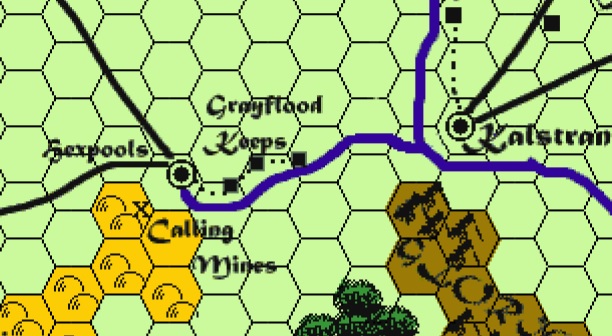
Summary
The Greyflood Keeps and their relative distances to each other, and to Hepools. cartography by Kent Matthewson.
Licensing
This copyright image is an illustration of a place or region in a roleplaying game, comic book, video game, television program, or film. The copyright for it is most likely held by either Wizards of the Coast and/or artist(s) producing the work in question. It is believed that the use of low-resolution images of copyrighted cartography:
| |
| Non-free media information and use rationale for Grayflood Keeps | |
|---|---|
| Description |
A piece of a map of the South Province of the Great Kingdom |
| Source |
Ivid the Undying, by Carl Sargant, Cartography by Kent Matthewson. Derived from a digital capture (photo/scan) of the PDF map (creator of this digital version is irrelevant as the copyright in all equivalent images is still held by the same party). Copyright held by the publisher or the artist. Claimed as fair use regardless. |
| Article | |
| Portion used |
Just the area around Hexpools which shows the Grayflood River; a small portion of the commercial product. |
| Low resolution? |
The image is of a size and resolution sufficient to maintain the quality intended by the company or organization, without being unnecessarily high resolution. |
| Purpose of use |
The image serves as the primary means of visual identification of the subject (the settlements) and their relative locations, in conjunction with discussion of the topic of the article. It illustrates educational articles about the map from which the image was taken. |
| Replaceable? |
No other version of this map wa published, so the image cannot be replaced by a free image. |
| Other information |
Compliant with the WotC Fan Content Policy and Fair Use. The use of the image will not affect the value of the original work or limit the copyright holder's rights or ability to distribute the original. In particular, copies could not be used to make illegal copies of the product. |
File history
Click on a date/time to view the file as it appeared at that time.
| Date/Time | Thumbnail | Dimensions | User | Comment | |
|---|---|---|---|---|---|
| current | 11:14, 2 August 2023 | | 612 × 336 (96 KB) | LHawk99 (talk | contribs) | Non-free use rational {{{Description}}}-A piece of a map of the South Province of the Great Kingdom {{{Source}}}-Ivid V, by Carl Sargant, Cartography by Kent Matthewson {{{Portion}}}-Just the area around Hexpools that show the Grayflood River {{{Low resolution}}}-yes {{{Purpose}}}-To show the placement of the keeps {{{Replaceability}}}-Not that I know of |
You cannot overwrite this file.
File usage
The following page uses this file: